LISFLOOD-FP
Contact: Paul Bates
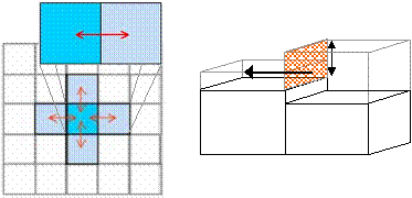
LISFLOOD-FP is a two-dimensional hydrodynamic model specifically designed to simulate floodplain inundation in a computationally efficient manner over complex topography. It is capable of simulating grids up to 106 cells for dynamic flood events and can take advantage of new sources of terrain information from remote sensing techniques such as airborne laser altimetry and satellite interferometric radar.
 The model predicts water depths in each grid cell at each time step, and hence can simulate the dynamic propagation of flood waves over fluvial, coastal and estuarine floodplains. It is a non-commercial, research code developed as part of an effort to improve our fundamental understanding of flood hydraulics, flood inundation prediction and flood risk assessment.
LISFLOOD-FP has been used as a research tool:
- within the pre-operational European Flood Alert System (EFAS) being developed by Dr. Ad De Roo at the EU Joint Research Centre,
- as part of the RASP tiered methodology for flood risk assessment being developed on behalf of the Environment Agency of England and Wales and DEFRA
- and for research studies at a number of institutions, including Ohio State and the University of Washington in the USA and the University of Messina in Italy.
LISFLOOD-FP has also stimulated the development of a number of academic and commercial codes based on its principles including:
- MDSFLOOD, developed by University of Bristol for Halcrow Ltd as a storage cell code demonstrator.
- JFLOW, developed by JBA Consulting as a broad-scale flood risk assessment tool and used, among other projects, to produce the Extreme Flood Outline maps for the whole of the England and Wales on Behalf of the Environment Agency and as a generic method for the Scottish Executive.
- FLOWROUTETM, developed by Ambiental Risk Analytics as a flood risk assessment tool for the insurance and planning industries on behalf of clients including Norwich Union, Aon and BP.
- Numerous research codes including those developed by Venere and Clausse (2002), Dhondia and Stelling (2002), Coe et al., (2002), Bradbrook et al. (2004) and Yu and Lane (2006 a and b). For references please see the LISFLOOD-FP heritage page.
